
We did this hike Sunday, September 10th. It was just Curtis and I.
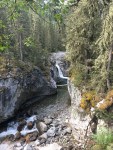
After an entire summer of no hiking due to knee injury, forest fires, and selling 2 houses (and buying a house); we finally managed to get out for a hike. Both of us have always wanted to do this one because it’s easy and the waterfalls are beautiful.
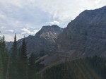
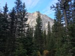
We got a really early start (at the trail head by 7:15am). Surprisingly, we weren’t the first here. Since there are lots of back-country campgrounds, the parking lot was busy and it is a popular hike. The trail goes from one side of the mountain range to the other through Burstall Pass. It could be done in 1 day, but it would be a very long day of hiking. We only went half-way and it was 26 km round trip (but only 6.5 hours).
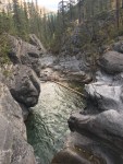
The first 11 km of the trail is designed for backpackers. It’s wide, gentle uphill, and no real issues to go around. That valley was quite destroyed during the 2013 floods as all the bridges were new. There must have been about 5 bridges that crossed the creek in this first 11 km.
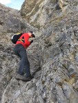
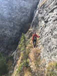
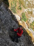
The next 2 km after the campground, is a lot of vertical gain. In 2 km, we gained about 800 feet in elevation. There are some pretty spectacular views of the valley below while climbing up. There is one section that the only sensible way up is to climb with a chain (that someone kindly anchored into the rock face). Without this chain, you would have to boulder up and down, which may be sketchy since there isn’t many footholds or handholds. This was probably the most exciting portion of the hike because you felt like you were hanging onto the side of the mountain (and you were). We met a few people coming down, so we had to wait since there is no other way around. So if you are going, I recommend going super early to avoid a congestion at the chains, or being prepared to wait.
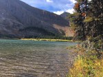
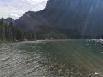
After the chains, we made it to the pass and the lake. The lake was crystal clear and I’ve heard that it is stocked with fish; whether that is true or not, I am not entirely sure. We found a little bench and ate lunch by the lake in the sun (which seemed to only grace us during this portion since the valley was so far down and hidden from the sun). It was a nice break because we didn’t see any other hikers or backpackers there. After resting for about 30 minutes, we made our way back down the chains and the valley. For being a popular hike, we didn’t run into too many people on our way down. It was surprising since the parking lot is usually packed.
In Summary:
I enjoyed this as a first hike back but it was a bit too long for not doing any hiking in 3 months. 26 km is a long ways when you haven’t hiked much more than 10 km in a week. I would hike it again but do the pass and park a car on the other end so you can get the full experience of Buller Pass. I would also come to this backcountry campground sometime next year.


I was just talking to your mother and told her I haven’t gotten a blog from you lately.
She told me know busy you have been. Once again, your pictures are beautiful. But, the one where you (or Curtis) was walking towards the waterfall on that ledge was pretty scary! So was the rock climbing. Does your mother get your blog?
I’m happy you took the time for this hike with all you have going on.
It looked amazing!
LikeLike
Lol thanks Pat!
Ya she sees my blog. That picture was of Curtis. It was pretty neat to see the little tiny trails hugging the cliff. Felt like a true mountain goat in spots!
Sent from my iPhone
>
LikeLike