Mount Blakiston is located to the west of Waterton townsite. We left at 7am on Saturday May 2nd, and drove for 3 hours. The drive was cloudy and we anticipated that there would be rain or worse, snow. However, when we arrived, it was sunny and warm at the trail and cloudy everywhere else!
Some sites and books mark this hike at 4 hours… You would have to run through it to make it in 4 hours. This time I went with my good friend Chris. This was his first hike of the season and so I didn’t want to kill him right away 🙂 The hike is marked as easy and I would say that’s a fair assessment.
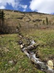
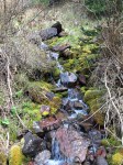
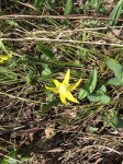
When you first set out, the path is a nice quick pace. You don’t climb much for the first 10 minutes. After you turn a few corners, it opens up into a field…on a mean slope. This is where you do the majority of the climb up. It’s a very narrow walking path but it’s definitely not difficult. There are lots of little creeks coming down from the hill to cross, but there are large stones that were placed there for hikers. We travelled along and up this slope for a good km. there are lots of crocuses and these red flowers that I am unfamiliar with; there were also yellow flowers that were quite nice. At one point, the entire side of the hill was littered with these yellow flowers.
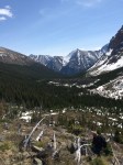
After the fields, you are led into a forest. Through your the forest we saw signs of diseased pine trees that were cut down; I assume pine beetle has made its way here. The path had some snow in sections but was mainly clear. It was a nice hike and we did not have much of a job of climbing.
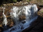
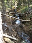
Throughout the forested areas, it would give way to crevasses that looked like Avalanche or flood channels. Lots of trees that were swept down and giant boulders. The path winds down one side and up the other. There is a nice waterfall and sitting area that’s very secluded. It’s a great place to stop for lunch. The sun hits it all day so it’s quite warm.
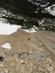
Once we got closer to the trail end (about 30 min to an hour after the small waterfall), we ran into snow. I don’t think it was leftovers but rather from frequent avalanches. We saw at least 4 fresh (within a week) avalanches in the area. Luckily for us, there was hardly any snow above us, only one section had snow pack. We trenched through snow, sinking up to our knees or thighs in areas (reminded me of Cascade!). It was a bit harder than Cascade to get through the snow only because it was all very uneven so one step made you slide sideways when the next step had you sinking.
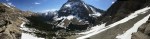
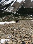
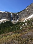
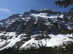
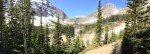
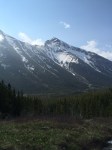
When we made it to trails end, we stood at the base of 2 mountains and a giant wall. There were two paths, one that led to the waterfalls and wall, and the other that led elsewhere (I later read that this one went to the other mountain). We chose the one to the waterfalls, however; an avalanche took the trail out so we ended up forging out own. I led and scouted for easy passages up. It started fine but soon grew difficult. The shrubs gave way to boulders which gave way to scree. We had a hard time getting any sort of footholds. I was fortunate that I found a mountain sheep trail that zig zagged part of the way up. We followed it until it disappeared (I think some sheep were abducted)…. On the far cliff wall, there was a beautiful waterfall. The sounds of the crashing echoed throughout the entire bowl.
While I enjoyed the scree and the scrambling, it was hard to find my footing. You would take a few steps and then slide down almost what you gained. I need to invest in some learning time on how to properly ascend scree. At the base of the cliffs, which from a distance looked smooth, we could tell that it was anything but. There were plenty of places to start climbing, even some easy places. I did manage to climb up a bit to a small overlook, but didn’t dare going further; the wind had picked up and the sun was starting to go down (it was around 2pm. We had a 3-4 hour return trip so I didn’t think it would be wise to continue much further). When I looked out over what we had accomplished, I noticed that on top of the wall to the North West of me, there sat a lake. It was still covered in snow, so this would be another postponed hike until summer to see the lake and reach the summit.
The ride down was quite easy. We skied the scree (with our feet turned sideways), so we were able to make it back to the Trails End within a matter of 30 or so minutes. That part was a lot better than going up! We followed the trail back. Still saw no wildlife; maybe the parks people forgot to release them? I dunno…
In Summary:
The trail itself was easy up to the trails end. This would be a good start for someone who is new to hiking or would like to warm up. The total trip time was around 7 hours. It would of been around 5.5-6 hours if we stopped at the Trails End; but what kind of hiker would I be if I didn’t challenge myself! (Edited): Turns out that we parked in the Mount Blakiston trail head lot instead of Lineham.